Pages

December 29, 2010

Yishun to Woodlands along the Mandai and SLE Park Connector

The Route

Map data ©2020 Google

We started from Chong Pang Village and headed south along Sembawang Road to Mandai Road, explored Track 15 at the junction of Mandai Road and Mandai Lake Road. Then backtracked to follow along Ulu Sembawang Park Connector turned left at SLE PCN to Singapore Sports School and the Woodlands Station.


This statue of a farmer hard at work is at the junction of Sembawang Road and Yishun Ave 5. This is also near the hottest Toto booth with the largest number of lucky winners.


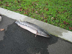
We came across two fishing enthusiasts who had taken the day off from work to indulge in their hobby. One of the fish caught along the shore of Seletar Reservoir.


The start of the Central Catchment Park Connector. It runs parallel to Track 15 that leads to the rifle shooting range. Although at the start of this trail, the track looks comfortable but as we walked further in, it becomes more close to nature, with fallen branches,  less gravel, etc.
.

At the junction of Track 15 and Central Catchment Park Connector. If we were to proceed further into the trail, it would lead to the Gangsa bike trail and Bukit Panjang area.

A billboard at the junction of Mandai Road and Mandai Lake Road, the road leading to the Zoo.


The Ulu Sembawang Park Connector. This trail was just opened. It provides a view of the Mandai forests and the nearby farming industries.


Along the SLE Park Connector. It runs along a wide open field before the Singapore Sports School. The sky was threatening to rain. We were worried about thunder and lightning as we were on raised and exposed ground.


A view of the Singapore Sports School from the SLE Park Connector. You can see the dark clouds behind the school. As soon as we reached the Woodlands MRT Station the sky opened up.

December 13, 2010

From Seletar to Punggol via Pulau Punggol Barat and Timor

The Route
 
Map data ©2020 Google

There are 2 islands off the northern coast of Seletar Airport. Google Maps indicate a new road linking Seletar across these islands to Punggol. This route was planned to explore the area.


View from Seletar West Link across to Yishun
We started from the prata shop in Jalan Kayu after a meal of Indian dishes and prata. Walked along Jalan Kayu to West Camp Road and followed it all the way to the airport. Near the Seletar Club Road we moved on to the Seletar West Link which runs parrallel to W Camp Rd but separated by a canal.


Seletar Airport

Walked along Seletar West Link, crossed the bridge leading to P Punggol Barat and continued on to Seletar North Link.

Seletar West Link ends at the bridge connecting Pulau Punggol Barat to the mainland and becomes Seletar North Link beyond the bridge. There were earthworks being done on the island. All day long hundreds of trucks carrying sand and concrete moved continuously on the road. As the road here is exposed, there is a risk of either sun/dust or thunder/lightning. If there had been lightning we would have walked across the dam linking to Yishun and walked towards Yishun. On that day, we were lucky as there was light rain that kept the dust down and the air clean and no lighting.
Truck transporting sand
A dam joins P Punggol Barat to P Punggol Timor. Another dam joins P Punggol Timor to Punggol. These dams hold back the Punggol River to form another reservoir.


Standing on the dam joining the two islands
Pulau Punggol Timor is used for stockpiling sand and granite. These can be seen piled as high as 4 to 5 metres.


Sand stockpile

There are also a few concrete mixing plants on Punggol Timor which explained the concrete trucks movement.


Punggol Marina

Traffic is prevented to move to Punggol mainland by a barrier near the dam. Trucks moving sand and concrete have to use Seletar West Link and Seletar North Link.

After crossing the dam joining the island back to the mainland, we could see Punggol Marina on the left.

See Also:
Along Lower Seletar Reservoir
Mandai Road and Sungei Seletar
Yishun to Woodlands along the Mandai and SLE Park Connector

November 24, 2010

Along Lower Seletar Reservoir

The Route
  • From Yishun Station walk south along Ave 2 to Bottle Tree Park
  • Walk eastward along Yishun Ave 1 past Orchid Country Club to the dam across Lower Seletar Reservoir to Seletar Club Road.
  • Return along the same way on Yishun Ave 1 turn right at Yishun Ave 6 then left at Yishun Ave 11
  • Through Yishun Park and past the Khoo Teck Puat Hospital to Yishun Station

Bottle Tree Park Yishun
Bottle Tree Park
This was established after the success of Bottle Tree Village in Sembawang. The owners idea was a concept village with sports, recreation facilities, conference rooms, eateries and enjoying nature. The company was named after the bottle tree from Australia. This and other exotic and rare trees were imported at a cost of $100,000.

At Bottle Tree Park, enthusiasts can rent a rod for $25 and fish for several hours for fish and prawns at the fishing ponds. The eateries include BBQ, seafood and halal restaurants and a pub.

Yishun Ave 1
Lower Seletar Reservoir
Along this road is the Lower Seletar Reservoir Park where there is a pier and canoeing facilities. One can see the MRT line curving from Lentor Ave.

Further down the road is the union-run Orchid Country Club where Peach Garden Restaurant offers wedding packages.

Solar-powered lights along the reservoir
Yishun Ave 1 ends just after the dam that forms the reservoir. At the end of the dam the road turns to the right to the entrance of the Selectar Golf Club.Just next to this is a small park with solar powered street lights.

See Also:
From Seletar to Punggol via Pulau Punggol Barat and Timor
Mandai Road and Sungei Seletar
Yishun to Woodlands along the Mandai and SLE Park Connector

Map

View Yishun in a larger map

October 14, 2010

Mandai Road and Sungei Seletar

The Route
  • Start from bus stop B22 on Mandai Road.
  • Walk east on Mandai Road until the dam just before the Executive Golf Course.
  • Walk across the dam at the Seletar Reservoir through the park then back to Mandai Road to the junction with Upper Thomson Road. Turn right and walk along Sungei Seletar until Lentor Ave then left to Khatib Station

Mandai Road
Along Mandai Road
On the left was a protected area used by the army for training. We spotted some durian trees here. About 1.5km from the starting point on the left was the beginning of the Ulu Sembawang Park Connector. One could see the view of the Seletar Reservoir from here. On one occasion we came across an angler with his just landed catch. He said he was on leave to spend his time indulging in his pastime. Another 1.5km and Mandai Road starts to veer southward to the right following the reservoir shoreline. We could walk along the dam that held back the Upper Seletar Reservoir to the park.


Seletar Reservoir
Sungei Seletar
Sungei Seletar
This river was recently developed to enhanced its eco-system - less emphasis on bare concrete and more on encouraging plants to grow on its banks. On the northern side is a strip of forest. But beyond that the land was being cleared for future development. A few anglers were found engaging in their hobbies here.

See Also:
From Seletar to Punggol via Pulau Punggol Barat and Timor
Along Lower Seletar Reservoir
Yishun to Woodlands along the Mandai and SLE Park Connector

Map

Map data ©2020 Google

September 29, 2010

Along the Ulu Pandan Park Connector from N Buona Vista Road to Pandan Reservoir

The Route
1. Walk along the Ulu Pandan Park Connector from North Buona Vista to Ayer Rajah Expressway AYE
2. Cross over AYE to West Coast Road to Pandan Reservoir
3. Walk around Pandan Reservoir

From North Buono Vista Road to Clementi Road the river is concrete-lined. Ghim Moh Estates and the Holland Groove Estates can be seen on the right bank while the left bank is covered with forests.


Pedestrian Bridge Across Sungei Ulu Pandan
After crossing Clementi Road the banks are left in a natural state with vegetation covering the banks. Several notable bridges cross the river - a beautifully canopied pedestrian bridge, an old unused railway bridge and several highway bridges including one for the MRT rail line.


Unused Railway Bridge
The greenery gives a back-to-nature look on this stretch. Lookout for kingfishers and white egrets feeding in the canal. When we arrived at AYE, we had to walk through the International Business Park to reach an overhead bridge to get across it. As we proceeded southward, we eventually reached West Coast Road and the Pandan Reservoir.


Sungei Ulu Pandan

The Reservoir is deceptive because of a hidden curve in the shoreline making us think that the circumference is 4km. It is actually about 6km. It was exposed and at the time we were there, hot. Two dangers here i.e. heat or lightning.


Pandan Reservoir

Pandan Reservoir
Pandan Reservoir was formed by damming Sungei Pandan. The towns of Pandan Gardens and Teban Gardens are on one side and the industrial areas of Penjuru Road and Jalan Buroh on the other side. Facilities include canoeing, fishing and a gravel track for jogging.

Map

Map data ©2020 Google